Friday – July 20

Oberlin Inn & RV park, Oberlin, KS.  I had gone to bed early last night because I was worn out from the drive.  Thus, I woke up early and got the RV ready to leave.  Since I did not used a lot of water and there was no sewer connection at the site, it was easy to undo the connections.  The first hour and ¾ was and easy drive with clear skies.  Then I saw the storm clouds ahead and even a lightning bolt off in the distance to the left.  The area was very flat, so you can see for miles.  The next hour and a half was rain.  Only once did I need to use the high-speed wiper and most time, it was in low intermittent speed and the road was not even wet.  But, I saw at least three lightning bolts.  I was able to stop twice at rest stops for a bathroom break and then for lunch on I-80.  The exit where I turned off I-80 had a Pilot station and since I would need fuel before I got to another truck stop, I stopped and filled up.  The last 100 miles or so was on two-lane roads.  Fortunately, there was light traffic.  But after the fairly level I-80, these roads had lost of hills.  The new campground is different.  It really is a motel, but it has 7 spots for RVs.  Two of them are pull-thru.  I had my choice since I am only one in the campground.  There are no trees, so I have satellite TV, but there is nothing to block the sun and the RV is hot.  I have 50-amp, water, sewer, and good Wi-Fi.  I decided instead of replacing the extension and the connection from the tow dolly, I would hardwire the two sets of wires.  Now, I have a very long set of wires that I will need to be concerned about when I disconnect the car from the tow dolly and when I disconnect the tow dolly from the RV.  I spent the rest of the day working on the computer, updating my journal and blog and making a few more reservations.

Posted in Uncategorized | Leave a comment

Thursday – July 19

West Omaha/NE Lincoln KOA, Gretna, NE.  After a long drive yesterday, I had another long drive.  I woke up early and was ready to leave at 8:27.  The weather forecast called for rain and it did rain around 7:00.  But by the time I was ready to dump my waste water, unhook the utilities, connect the tow dolly, and load the car, it was not raining.  But shortly after I started to drive, it began to rain.  I am not sure which came first, the rain or the construction.  But for the first 45 minutes of the drive, it was raining heavily and the road was a two-lane highway (the other two lanes were closed for construction).  In addition to the heavy rain, the trucks going in the opposite direction threw water onto the windshield.  After the 45 minutes, I believe it let up sometimes, although I had to slow down at least once because the rain was that hard that the wiper on high speed could not keep up with the rain.  It finally stopped and the last two hours was mostly sunshine with some white clouds.  I was almost always on four lane roads (although there was sometimes construction closing two of the four lanes).  You would think that they would have rest stops along those roads, but except for one that was closed, I did not find any until I got to I-35.  I even had to pull into a business parking lot so I could use the bathroom in the RV.  Then Omaha was crowded with lost of hills, so I needed to get down into third gear at times.  I made it here by 3:33 and used the rest of the day to catch up on the computer and make reservations for the next week.  My site is small and I am next to there playground, but I had good Wi-Fi and cable.  However, I do not get all the channels they say I should get.  But I am too busy to watch TV.  I have an extension that I use to connect from the tow dolly wires to the wires in the car.  The tow dolly connection somehow fell to the ground and was dragged for some time which destroyed the two parts of the connection.  Hence, no tow lights in the car.

Posted in Uncategorized | Leave a comment

Wednesday – July 18

Minneapolis SW KOA, Jordon, MN.  It was a bad day today.  I wanted to leave early (8:00) so I could get back to the RV and update the blog.  But first, I had to go to the campground’s office and pay for the extra day.  It did not open until 9:00, so I had to go back to the RV and wait.  I decided I wanted to see the other two parts of the river today.  The park’s area included a prairie setting (upper section), a narrow rock walled setting (which I saw yesterday), and the normal Tom Sawyer Mississippi river.  I drove to the Cloquet Overlook Park.  Then I entered the town where the St. Croix River meets the Mississippi River.  Unfortunately, I hit the wrong line and went at least 75 miles out of my way (or at least I had to drive back 75 miles on the same road I drove on).  On my Prius’ GPS, you first enter the state, then the city, then the street, then the number.  To make things easier, after you have entered a few letters, if it can limit what the possible names are to six or less, it puts up a table of possible name and you can choose from the list.  With my large fingers, I hit the wrong entry, and instead of going to Prescot, I went to Preston.  (You should see me trying to enter on my phone with its little keys.)  At least I was able to see the town where the Mayo Clinic is located.  Then to make things worse, on the way back, I missed a speed limit sign and when I finally saw one, the moment I began to slow down, I saw the police car.  Fortunately, I only received a warning.  In over 55 years of driving, I have only received one speeding ticket, and then this made the second warning.  I drove back to where I had originally wanted to go.  I saw the St. Croix river and lake (the lake is right next to the mouth of the river).  But I could not get a good picture of the mouth.  On the north side was a heavily traveled road and then a railroad before you could get to the bank of the Mississippi.  I tried, but the bridges were in the way.  I saw some fishermen on a dock on the lake near the bridge.  The water was half way up their calves.  On the other side of the highway bridge was a private boat dock, so I could not get there either.  Again, I was back at the RV after 6:00.  I had driven 362.9 miles in 7 hours and 179 minutes, but at least I got 58.7 mpg.

Upper Mississippi

Upper Mississippi River portion of the park.

Show how high the water was

Fishermen on a dock of the St. Croix River.   The water is that high they are standing on the dock in the water.

Mouyh of St Croix

The closest I could get to the mouth of the St. Croix river with the Mississippi on the left.

Posted in Uncategorized | Leave a comment

Tuesday – July 17

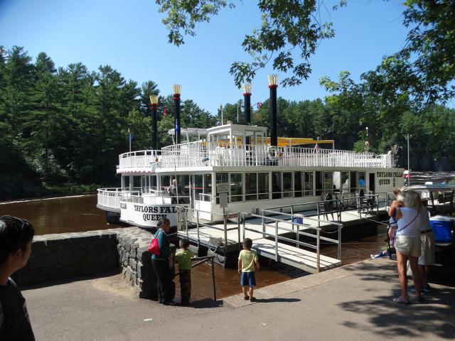
Minneapolis SW KOA, Jordon, MN. I drove to St. Paul and the Minnesota Science Museum.  This is where the ‘official’ visitor center for the Mississippi National River and Recreation Area is located.  When I got to the building, there were two guides waiting for a school bus load of children that were visiting the museum.  I asked where a parking lot was and they told me just a few feet ahead of me.  A post was blocking the parking sign.  I parked in a parking garage under the museum.  Since this is a fairly new park, they really do not have a lot of land where you can visit which is owned by the park.  It is mostly state and county parks under their umbrella.  I got my stamp, but they were out of stickers and did not have a movie.  They did have an interesting item.  If you stood in one spot and moved your arms like a bird, they projected you on the wall as an eagle flying over the Mississippi.  I asked about hiking or visiting places and they told me about three interesting places.  They also had a free booklet which show a detailed view of small sections of the river and interesting places in that section.  The first interesting place was a boat ride up the Mississippi.  The dock for the ride was across the river and there were two stern wheel paddle boats there.  I decided to walk that ‘short’ distance (it was 1.4 miles).  I first had to walk a block to the bridge over the river, then on the bridge over the Mississippi river over the bridge.  On the other side was a street that led to the boat dock, but there was no sidewalk.  I walked on the grass.  Finally, I got to a levee and climbed over it to a park and at the edge of the park was the boat dock.  The boat ride was not until 12:00, and the ticket window did not open until an hour before the boat leaves.  There was a group of women setting up a table.  Their company was having a company picnic on one of the boats.  I tried to join them, but even though I had worked for an electric company, it was not their electric company, so they declined.  Finally, the 10:00 boat ride came back and after unloading, we were allowed to get on board.  However, it was not a boat ride, it was a barge ride pushed by a tug boat.  The barge had two decks, with the lower deck mostly enclosed and the upper deck open.  We went about an hour upstream before turning around and heading back for a half an hour (it went faster going with the current).  One of the interesting things was a swinging railroad bridge.  When it was being built, it was a symmetrical structure.  But when they first wanted to try it, the land owner over which the bridge would swing refused to let them us the air over his land.  They had to rework the bridge with a short side weighted with concrete.  The land owner was an old river pilot who lost his job when the railroad came through and was not going to do the railroad any favors.  I should have taken my hiking pack with my lunch in it along with me when I came over, because I got hunger and had to buy a hot dog from the concession stand on the barge.  When we got back to the dock, I had to walk back to the parking garage.  Fortunately, I found a path that lead to an island and stairs that went up to the bridge, so it was a shorter walk (1.12 miles).  I was on the sixth level of the garage and I had to drive all the way down to the first level to get out of the garage.  Then I went to the second place.  It was the summer-only second visitor center at St. Anthony Falls lock and dam.  But they were working on the lock, so we could not go out on the lock itself but were able to see it from the third floor of the visitor center.  A ranger gave the talk he normally gave on the lock wall in the observation room.  This was the area of the greatest drop in the entire length of the river and had once been the location of water powered saw mills and then later flour mills.  Finally, I went to the third spot, the Minnehaha Falls.  This was the only remaining natural falls in the park.  You could see it from the top or go down the stair and see it from a bridge over the creek.  At the bottom, was a trail that lead to the mouth of the creek at the Mississippi River.  That was a 1.97-mile hike with a gain of elevation of 81 feet (climbing the stairs) in a little over an hour.  Parts of the trail was nice, but a few times, it was very narrow and at an angle.  I think I left the RV around 8:30 and did not get back until after 6:00.  I had originally planned to only stay two night, but then with the size of the park, I asked if I might be able to stay another day.  But I was too tired to go to the office and pay for the extra day.

Pretending to be an eagle

A young boy pretending to be an eagle.  The ‘eagle’ is in the bottom left of the screen.

Tug

The tug that pushed the barge.

Swinging Railroad bridge

The swinging bridge in the open position.  You can see the concrete counterweight to replace the section that had to be removed.

Swinging bridge closed

Swinging bridge in the closed position.  A train was waiting to cross the bridge.

Minnehaha falls

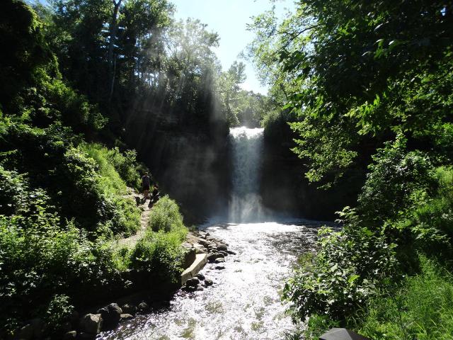
The Minnehaha falls.

Posted in Uncategorized | Leave a comment

Monday – July 16

Minneapolis SW KOA, Jordon, MN.  It was a short drive today, so I left late.  I worked on the computer before leaving.  I had planned to stop just before I got to I-35 for fuel, but there was construction there and I missed it.  I stopped at a rest stop shortly after I got on I-35 and checked an app on my phone which can tell me about truck stops.  It said there was one about 3 miles away at the next exit.  So, I took the exit, but did not see the truck stop.  There was a sign about diesel to the left, so I went left.  After a little while, I decided to turn around and check the other way.  But where I turned was a gas station which had diesel, so I filled it up there.  They had two nozzles at the diesel pump, one small one for cars and a larger one for truck (as RVs).  Back on the road, I got to Minneapolis and city traffic (on freeways).  There were plenty of slowdowns and traffic.  Finally, I got to the road where the campground was, and the traffic let up some.   My site at the new campground is at a corner, so I can leave my table’s shade open.  However, the view is their junk picnic tables. Unfortunately, I am writing this three days later, so I do not remember much from this date.

Posted in Uncategorized | Leave a comment

Sunday – July 15

Turtle Lake RV Park, Turtle Lake, WI.  I woke up and after breakfast, got ready for church.  It was less than 5 miles away.  It was a small congregation that was part of a three-church parish.  All of them are within 10 miles away.  Originally, one was German, one was Finnish, and one was Norwegian.  I believe there were less than 30 in attendance.  And it was a short service, with no readings.  But they did have communion.  Afterwards, I attended their coffee gathering and talked with a group of men.  Two of them go to Florida for the winter.  I asked about a grocery store, and was told that there was only one locally and that was about a half a mile from the RV.  So, after I got back to the RV and changed out of my suit, I went to grocery store.  Very few people were there because they were having a parade for their fair.  I went back to the RV, got my camera (in case I saw anything really interesting) and went to see the parade.  It needed to be better managed because there was a lot of empty spaces between the different participants in the parade.  Then I went back to the RV, had lunch, and then worked on the computer.  The campground’s Wi-Fi is not the best.  It sometimes comes and goes and is slow.

Posted in Uncategorized | Leave a comment

Saturday – July 14

Turtle Lake RV Park, Turtle Lake, WI.  I drove to the second St. Croix National Riverway to get their stamp and check on hiking trail in the area.  The ranger recommended two in the national park, but one was too short and she said the other was very buggy.  But she did recommend a paddle boat ride on the river.  I was not interested at first because I did not believe I had to correct shoes and clothing for a small boat ride.  But she told me that it was a large stern driven paddle wheel boat.  I decided to check it out.  It was in the Taylor Falls Interstate State Park across the river.  I went there and paid for my ticket.  It had two paddle wheels in the back that worked independently of each other.  In fact, when they were turning the boat around, the paddle wheels turned in opposite directions.  According to the announcer, during the last ice age, the normal path for the waters to leave Lake Superior was blocked by ice, so the huge amount of water that was backed up came down this valley and cut through the rocks creating interesting features.  It was a ninety-minute ride.  Being a Saturday with warm (actually, hot) weather, there were tons and canoes and kayaks on the river.  When we got back to the landing, I hike through the Glacial Pothole Area.  The water from the ice age created whirlpools which took the sand and small rocks are swirled them around, creating huge potholes.  This trail went through and around that area.  It was a .41 mile walk in just under a half an hour, but with a 44-foot gain in height.  Then, I had lunch before putting on my hiking shoes and hike the three other trails in the park.  The first trail was the River Trail, that went along the river.  Then, I took the Sandstone Bluffs Trail.  That climbed up to the bluff above the river.  It had over 200 stairs and the worst set was one that had been cut into a crack in the rocks.  It was uneven steps with no hand rails and no place to use my hiking poles.  I had to garb onto the sides of the crack to help pull me up.  I was not even sure this was actually part of the trail until I got to the top and saw that the trail continued on.  I should have taken a picture of it before I climbed up, but I was not going to go back down just for a picture.  Just before those stairs was a small water falls that was running because of the recent rains.  The rest of the way was fairly easy.  Then I got to the Railroad Trail.  This was had been a railroad bed, so after climbing up to the bed, was almost level the whole way.  In all, I hiked 3.14 miles in 2 hours and 9 minutes with a gain of 309 feet.  It was very hot and because of the rain yesterday morning, it was very humid.  By time I got back to the RV, I had drunk all the water I had taken with me which included my hiking backpack, a traveling mug, and my short hiking canteen.  I still drank more water when I got back to the RV.  I was so exhausted, I took a nap before I made supper.  The rest of the day was spent watching TV.  Sternwheelers

Sternwheelers at the dock.

Paddle wheels

Two paddle wheels.

Cross

Supposedly, there is a cross on the rock.  The missionary saw this as named the river Saint Cross in French – St. Croix.

Two of the many potholes.  First one is the bottom of one.  The second is to show how big they are.

Looks like it was made of wood

The rocks almost look like they were mad of wood.  This was almost at the top of the Bluff trail.

Posted in Uncategorized | Leave a comment

Friday – July 13

Turtle Lake RV Park, Turtle Lake, WI.  I had thought I had made arrangement for a RV park for today, but it was over the phone and I did not get a conformation.  So yesterday, I called the park where I had made my reservation but could only leave a message.  I even tried a second time.  So about 9:00, I called again and still got the voice mail.  So, I checked and found another park and they could take me.  I could even come as early as 12:00.  It was only a short drive, a little more than two hours, so I waited until 10:00 to leave.  The first part of the trip was bad – I got into a detour and then city traffic for a while.  I had driven this part of the road when I went to Apostle Island National Lakeshore last week.  Finally, I got to the open road and easy driving.  However, at first, I had to climb up to the plateau which still had hills and valleys.  About 50 miles still to go, I saw a sign for the St. Croix Namekagon River Visitor Center.  Since I wanted to go there anyhow for their stamp, I stop off.  In addition to the stamp and all the pamphlets, I saw their movie (with Walter Mondale) about the park.  Then I continued on my way.  I was beginning to see water along side the road and sure enough, it began to rain.  Fortunately, it was not hard, but I was concerned about having to set up the RV in the rain.  Finally, I got to the address where I had put into the GPS.  However, the address was wrong.  There were two highways in the address and I only put the second one in, so I was almost 10 miles short of the correct address.  I used my phone and got the correct location, so I continued on my way.  Then, I missed the turnoff and had to go around the block.  The office was in a liquor store about a block away, so I chose a site and parked the RV.  I walked to the liquor store and registered and paid for the site.  Then I went back to the RV and set it up.  Fortunately, it had stopped raining shortly before I had gotten to the park.  I have a few over-the-air stations, but since there are no tall trees near me, I have satellite TV.  It is a pull-thru site with water, sewer, and electric, but only 30 amps, so only one air conditioner.  And I needed it because of the humidity and also for the heat.  I also have good cell phone service and they have Wi-Fi, but the Wi-Fi is iffy.  It come and goes.  I checked out the pamphlets (they have 10 detailed one since the riverway is so long), then worked on the computer, trying to used the Wi-Fi, until I got tired and then watched TV.

Posted in Uncategorized | Leave a comment

Thursday – July 12

Indian Point Campground, Duluth, MN.  Since it was a short drive, I decided to visit the city’s visitor center to get directions to the dam.  The clerk tried to show me the way, but I am not sure she knew anything about it.  I finally stopped at a gas station, and they told me that the River Walk the clerk told me about did not exist anymore since the paper mill had expanded along the river.  But, I was able to check my map and found a spot where I could at least see the International bridge across the river which was supposedly over the dam.  I went back to the RV and finished getting ready to leave (load the car and unplug the electric).  It would have been a nice drive except that it was windy and both Virginia and Duluth had heavy traffic.  I got good mileage, especially since towards the end, I had a long hill with the engine brake on the whole time.  I discovered why I did not have good Wi-Fi connection when I was here the first time.  My system thought that the Wi-Fi was not safe, so did not connect.  I corrected the problem and caught up on emails and updates.  Around 6:00, my nephew came by and we went out for supper.

Posted in Uncategorized | Leave a comment

Wednesday – July 11

Arnold’s Campground and RV Park, International Falls, MN.  I woke up to a thunder storm.  I had a paper that said that the one visitor center had a lake cruise at 10:00, so I got ready to get there in time to go.  The rain stopped long enough that I was able to load the car and start driving without getting too wet (using a rain poncho).  But as soon as I started driving, it began to rain hard, that hard that I needed to have the windshield wipers on high and that was almost not enough.  When I got to Kabetogama Lake visitor center, the rain had let us and then stopped.  I asked if the cruise was still on, but there were waiting for the captain.  They ranger wanted to check me in.  That was when I discovered that the cruise was booked full and book full for the next two weeks.  Even the other cruise at the other visitor center with a larger boat was also book full for that length of time.  So, I got my stamp and watched their movie hoping that one of the people for the cruise would not show up because of the weather.  No such luck.  They had a canoe trip about a half an hour later with ‘voyageurs’ leading the trip.  Because of the wind, they did not go out on the water, but the reenactors went through the show as if they were getting a crew ready to go out.  I stayed long enough for the show until they went down to the canoe.  Since I had canoed the Boundary Waters for a week as a scout leader, I did not need those instructions.  Then I went to the Ash River visitor center.  I got their stamp (same movie) and a trail map for Blind Ash Bay trail there (the first center did not have a good trail there).  I hiked 3.09 miles in a little over 2 hours.  It was a nice trail, most of the time fairly level, but it did have a 222 ft change in elevation.  There was a nice overlook at the far end of the trail.  Then I drove back to International Falls and the Rainy Lake visitor center for their stamp.  They also had a short trail there.  The Oberholtzer Trail was interesting.  Beside the trail map I received, they had metal maps at each intersection or bench, so I really did not need the map.  That was a 1.82-mile hike in just under an hour.  The lookout at the far end was just a grassy field or maybe an overgrown pond, but the trail was fairly level.  Finally, I went back to International Falls to see the falls.  I had been told that it no longer exist since they dammed the river for the two paper mills (one on each side of the river).  But I could not find the dam either.  I went back to the RV and rested.  Those two hikes had worn me out.

Voyageurs

Two rangers dressed like French Voyageurs.  Funny, I thought the voyageurs were all male.  These two were not.

Blueberries

Blueberries along the side of the trail.  I was surprised that something had not eaten them already.

Posted in Uncategorized | Leave a comment